Wet weather throughout Idaho, including snow at higher elevations, has largely ended the active fire season, but some closures could still remain in some areas, particularly the Clearwater Region, which had the most fires this summer.
Please follow links for more details.
F&G has more detailed information on links on its Fire Information Page.
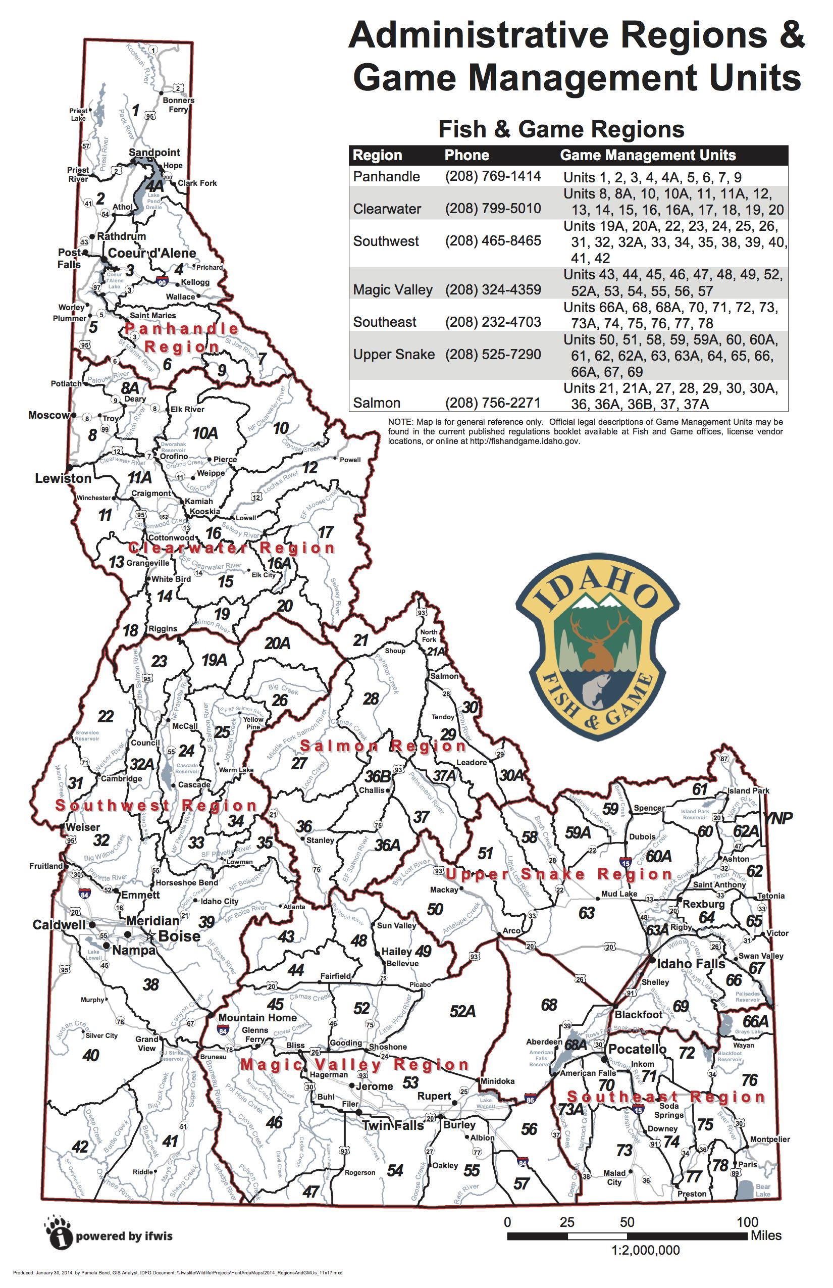
Here's a statewide map and overview of fires and hunting units.
Updated Sept. 22 (See below for a map of regions and hunting units)
Panhandle region
Fire restrictions have been lifted.
Clearwater Region
As the Nez Perce-Clearwater National Forest continues to receive widespread precipitation in the form of rain and snow, fire-related area, road, and trail closures continue to be rolled back.
An order closing 35 trails within the Selway-Bitterroot Wilderness of the Moose Creek Ranger District has been rescinded and those trails are once again available for public use. Roads and trails in the vicinity of Coolwater Ridge east of Lowell have also reopened.
Remaining closures are being evaluated daily and visitors are encouraged to visit the Forest’s website or contact the appropriate District Office for up-to-date information.
Southwest Region
Hunters now have access to all of the Middle Fork Elk Zone – units 20A and 26. While the Highline and Goat Fires continue to burn in the Frank Church River of No Return Wilderness Area, fire danger is minimal, though hunters are still advised to exercise caution when near the active fire line.
The www.rxfire.com website is updated with information regarding southwest Idaho burn planned within Idaho Department of Lands, Bureau of Land Management, Payette National Forest and Boise National Forest.
Weather and conditions permitting, prescribed burns are scheduled to start in September and continue through November. Approximately 2,400 acres are planned for ignition in nine project areas within the Boise National Forest.
Prescribed burns may affect may impact access to burn areas and travel routes. Beware of firefighters and equipment in the area and on roadways and comply with posted notices.
Information and signs will be posted on roads that access burn areas in advance of ignitions and remain in place through burn completion
The Boise National Forest prescribed fire hotline: (208)-373-4208.
Planned Boise National Forest fall prescribed burns include:
Idaho City Ranger District
Warm Springs Ridge (200 acres): located approximately 4 miles west of Idaho City, Idaho. Prescribed burn using hand ignition to reduce surface vegetation (fuels).
Mores South (50 acres): located about 3 miles east of Idaho City, Idaho. This is a landscape burn (ground fire) using hand ignition to reduce fuel in the Wildland Urban Interface.
Alder Ridge (100 acres): located 1 mile north of Placerville, Idaho. This is a landscape burn (ground fire) using hand ignition to reduce fuel in the Wildland Urban Interface.
Little Ophir (100 acres): located 4 miles west of Pioneerville, Idaho. A landscape burn using hand ignition that will reduce fuel in the Wildland Urban Interface area.
Warm Springs Aerial (600 acres): located 4 miles west of Idaho City, Idaho will use a helicopter and hand ignition to reduce fuel in this wildland urban interface.
Amber (300 acres): located 2 miles east of Idaho City, Idaho. This is a modified tree well burn.
Cascade Ranger District
Horsethief (360 acres): located about 1 mile east/northeast of Horsethief Reservoir. This burn involves helicopter and hand ignition to reduce fuels over the area.
Westside Restoration Unit 39 and 40 (consist of 25 acres each): This project is located on National Forest System (NFS) road 435 along West Mountain. It is approximately 10 miles west of Cascade, Idaho. This will be hand ignition to reduce fuels within the wildland urban interface.
Amanita Campground Landing Piles: This project is located approximately 25 miles west/northwest of Cascade along the West Mountain road. It will be pile burning for one day.
Administrative sites: Slash piles will be ignited in the following locations: Warm Lake, Yellow pine, Landmark and Crawford. It will be pile burning for two days.
Mountain Home Ranger District
Cottonwood II Rx (1000 acres): This project is located about 17 miles NE of Boise, Idaho along NFS roads 203 and 377.
Lowman Ranger District
Administrative Sites (20 acres): (Lowman and Elk Creek Guard Stations)
Wapiti Summer Homes (10 acres): (Grandjean area)
Bear Valley/Elk Creek (5 acres): (scattered piles)
Long Creek Summer Homes (1 acre): (Junction of NFS roads 582/545)
Emmett Ranger District
West Scriver Landing Piles: This project is located about 7 miles north of Crouch, Idaho, in the Scriver Creek drainage. It will be pile burning for one day.
Pinney Slope Landing Piles: This project is located about 6.5 miles north of Crouch, Idaho, in the Pinney Creek drainage. It will be pile burning for approximately five days.
Sagehen Admin Pile: This project is located directly west of Sagehen Reservoir and will take one day to burn.
Williams Creek Landing Piles: The project area is located west of Idaho State Highway 55, between Banks and Smiths Ferry, Idaho. The project area is located entirely on NFS lands in Valley County, Idaho, Township 10 N., Range 3 E. Sections 4, 5, 8, 9, 16, 17, 19-21 and 29-31, the Boise Meridian. It will be pile burning for approximately five days.
Garden Valley Admin Pile: This project is located at the Garden Valley Forest Service site 3 miles east of Crouch, Idaho. The project will be approximately two days of burning.
Magic Valley Region
No fire activity.
Southeast Region
Currently no wildfires in the region.
Upper Snake Region
Currently no fires in the region.
Salmon Region
Trail closures in Unit 27 west of Challis caused by the Ibex Fire and Honeymoon fire have been lifted.
Fish and Game's policy on hunts that are affected by fires
Hunters have the option of exchanging tags at any Fish and Game regional office, but they must do so before their hunt starts.
All hunters should consider that fire conditions can change quickly with favorable weather and forests can reopen. Fire season tends to taper off by late September and is usually over by mid-October when most any-weapon hunts start.
Fish and Game's standard policy is to not change hunts or rules due to fire closures because entire hunting units are rarely closed, and fire restriction rarely last through the entire hunting season, however, in rare cases rain checks are issued if an entire hunt unit is closed and will likely be closed throughout the season.