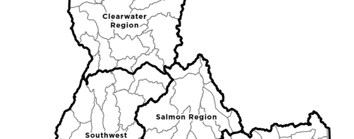
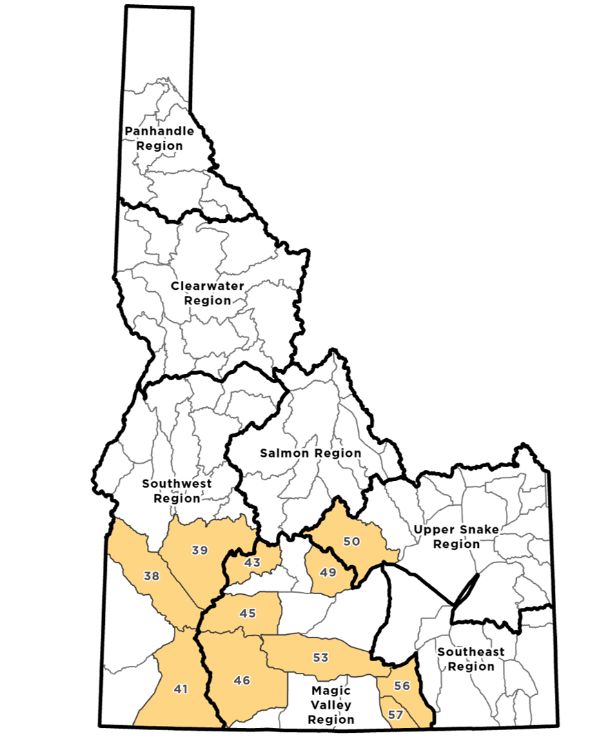
The changes were made to several Game Management Units, which in turn impacted elk zones and controlled hunt areas. This resource is intended to highlight these adjustments.
Changes are listed below by Game Management Unit and Elk Zone below. Changes are grouped below as:
- Observable Changes to GMUs
- Clarifying Changes to GMUs
- No changes to GMUs
- Elk Zones Impacted from GMU Changes
- Controlled Hunt Area Information
Observable Boundary Changes
These changes were along borders between the following Game Management Units.
Click unit to see more information
- Unit 38
- Unit 39
- Unit 41
- Unit 45
- Unit 46
- Unit 49
- Unit 50
- Unit 53 [53 western] - [53 eastern]
- Unit 56
- Unit 57
Clarifying Description Changes
The following Game Management Units focus on clarifying descriptions of locations.
- Unit 5: Change reference to “Mashburn” instead of “Washburn”
- Unit 5
- Unit 6-7: Provide clarity on how to get from Avery to the Fishook Cr. Road (reference to “Milwaukee Road and Siberts Old River Road”)
- Unit 6
- Unit 7
- Units 40, 41, 42: Remove references to Poison Creek and Deep Creek Cliffs Road and add Juniper Mountain Road.
- Unit 40
- Unit 41
- Unit 42
- Units 44-48: Remove unnecessary wording and separate Camp Creek Rd. and Croy Creek Rd. for clarity.
- Unit 43
- Unit 44
- Unit 45
- Unit 46
- Unit 47
- Unit 48
- Units 60-60A: Clear up description of boundary using current road names.
- Unit 60
- Unit 60A
No Changes to GMUs
The following Game Management Units have no changes.
- Unit 1
- Unit 2
- Unit 3
- Unit 4
- Unit 4A
- Unit 8
- Unit 8A
- Unit 9
- Unit 10
- Unit 10A
- Unit 11
- Unit 11A
- Unit 12
- Unit 13
- Unit 14
- Unit 15
- Unit 16
- Unit 16A
- Unit 17
- Unit 18
- Unit 19
- Unit 19A
- Unit 20
- Unit 20A
- Unit 21
- Unit 21A
- Unit 22
- Unit 23
- Unit 24
- Unit 25
- Unit 26
- Unit 27
- Unit 28
- Unit 29
- Unit 30
- Unit 30A
- Unit 31
- Unit 32
- Unit 32A
- Unit 33
- Unit 34
- Unit 35
- Unit 36
- Unit 36A
- Unit 36B
- Unit 37
- Unit 37A
- Unit 51
- Unit 52
- Unit 52A
- Unit 54
- Unit 55
- Unit 58
- Unit 59
- Unit 59A
- Unit 61
- Unit 62
- Unit 62A
- Unit 63
- Unit 63A
- Unit 64
- Unit 65
- Unit 66
- Unit 66A
- Unit 67
- Unit 68
- Unit 68A
- Unit 69
- Unit 70
- Unit 71
- Unit 72
- Unit 73
- Unit 73A
- Unit 74
- Unit 75
- Unit 76
- Unit 77
Elk Zones
Elk zones and controlled hunt areas are defined from Game Management Units. The following elk zones were impacted by Game Management Unit boundary changes:
- Boise River Elk Zone
- GMUs: 38/39
- Observable: This change is within the city of Boise, bordering the Owyhee Elk Zone.
- GMUs: 39/43
- Clarifying: A definition change to make it easier to identify boundary along Fall Creek road adjacent to Smoky-Bennett Elk Zone.
- GMUs: 38/39
- Owyhee Elk Zone
- Pioneer Elk Zone
- GMUs: 49/50
- Clarifying: No changes to the Pioneer Elk Zone. The 49/50 unit boundary adjustment is completely within the elk zone.
- GMUs: 49/50
- Smoky-Bennett Elk Zone
- GMUs: 53/56/57
- Observable: A change near Bliss adjacent with the Snake River Elk Zone.
- GMUs: 39/43
- Clarifying: A definition change to make it easier to identify boundary along Fall Creek road adjacent to Boise River Elk Zone.
- GMUs: 53/56/57
- Snake River Elk Zone
- South Hills Elk Zone
- GMUs: 41/46
- Observable: This change is along the Jarbidge river boundary with South Hills Elk Zone
- GMUs: 41/46
Controlled Hunt Areas
Controlled hunt areas can use Game Management Units as part, or all, of their area descriptions. Please check the boundaries of your controlled hunt area in the Idaho Hunt Planner.
Observable Boundary Changes Details
The changes were to the boundaries along these Game Management Units:
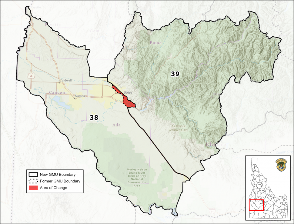
GMUs 38 and 39
General Location
Within the city of Boise.
Change
Change the description of “to Boise” to: …and then east on West State Street, to and then east on East Warm Springs Avenue (by way of Avenue B and E Parkcenter Blvd), to and then south on State Highway 21 to Interstate 84…
Justification:
- Shifting GMU 38 north would align that portion of Boise in GMU 39 with the management style of GMU 38 while still providing a clean line. The current description is “to Boise” which leaves it open for interpretation as to how to get to Interstate 84. This alternative would further define the GMU delineation and include a larger portion of Boise into GMU 38.
Back to top
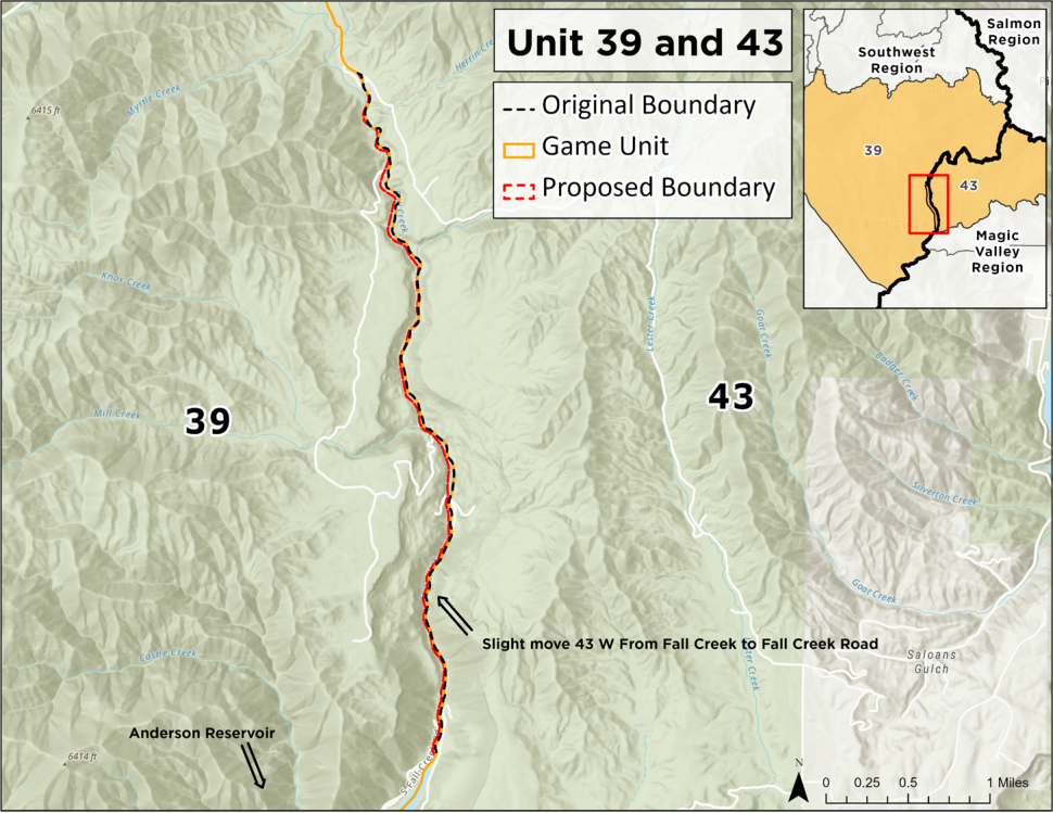
GMUs 39 and 43
General Location
Along Fall Creek Road, north of Anderson Reservoir
Change
Shift a portion of the GMU boundary from Fall Creek to Fall Creek Road and revise boundary description to include current US Forest Service designated route numbers and County road names.
Justification:
- Revision would more clearly define the unit boundaries for the benefit of hunters and the practicality of enforcement.
- Changes reflect current numbering of US Forest Service designated routes and County road names.
Back to top
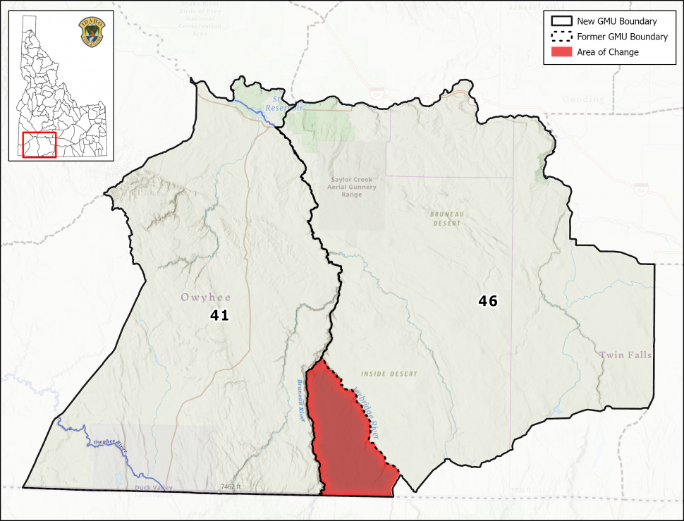
GMUs 41 and 46
General Location
Between the Bruneau and Jarbidge rivers in Owyhee County. This change is central on the southeastern side of unit 41 and southwestern corner for GMU 46.
Change
Shifts “Diamond A” portion of GMU 41 (Region 3) to GMU 46 (Region 4)
Justification:
- Access to the Diamond A portion of GMU 41 (between the Bruneau and Jarbidge Rivers) is faster and easier from the Magic Valley Regional Office than from Nampa Regional Office.
- The area is inaccessible from the western side during the winter.
- Because of access, this portion of GMU 41 is already included in several GMU 46 hunts.
- The Magic Valley Region already conducts all wildlife surveys in the Diamond A, including sage-grouse and bighorn sheep.
Back to top
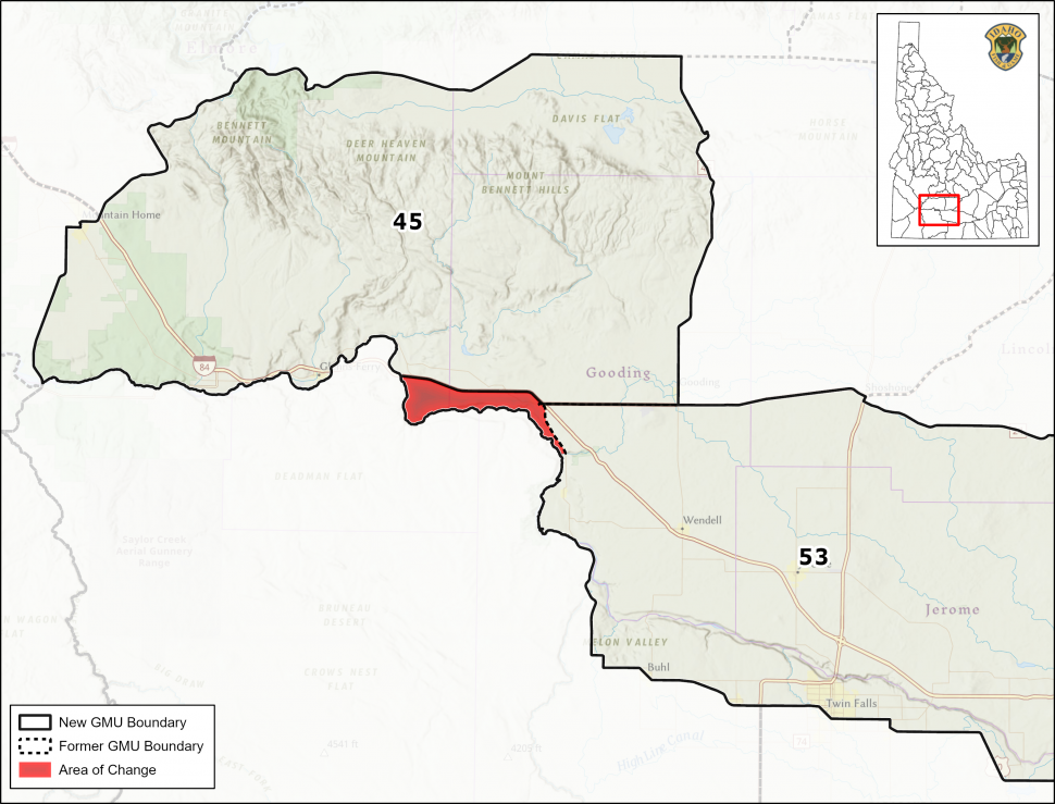
GMUs 45 and 53
General Location
This is the western change of unit 53.
Change
The proposed wording would shift that portion of GMU 45 between I-84 and Snake River from King Hill to Bliss to GMU 53.
Justification:
- This portion of the existing boundary is difficult to describe and understand which results in confusion from the hunting public and hunting rules compliance issues, particularly for mule deer.
- Proposed boundary change is much easier to describe and understand because it now follows I-84.
Back to top
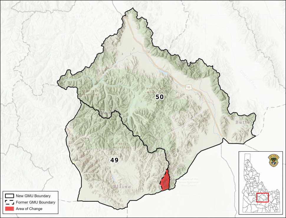
GMUs 49 and 50
General Location
Barn Canyon
Change
Shifts unit boundary from Copper Creek to the watershed divide between Copper Creek and Cottonwood Creek
Justification:
- Copper Creek has minimal flows and is difficult to determine where the actual drainage is.
- This is the only segment of the boundary that does follow the Little Wood /Big Lost divide.
- Access to this area is much better from the Magic Valley Regional Office than from the Upper Snake.
- The Magic Valley Region already conducts all wildlife surveys and manages all big game depredations and landowner relations in this portion of Unit 50.
Back to top
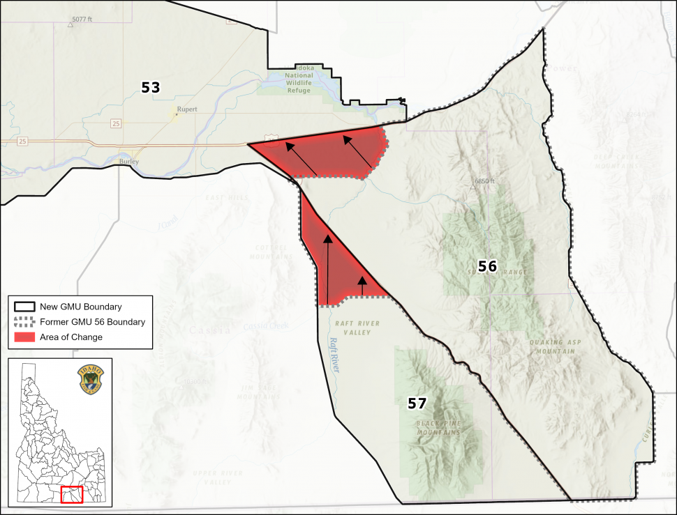
GMUs 53, 56, and 57
General Location
This is the eastern change for unit 53.
Moves portion of GMU 53 south of I-86, east of I-84 and north of the Yale Road to GMU 56 and moves that portion of GMU 56 West of I-84 and northeast of Malta to GMU 57.
Change
Moves portion of GMU 53 south of I-86, east of I-84 and north of the Yale Road to GMU 56 and moves that portion of GMU 56 West of I-84 and northeast of Malta to GMU 57
Justification:
- Existing boundaries are difficult to describe and understand, resulting in recurrent expenditure of staff time to educate the public and enforce rules associated with a small portion of Unit 53, 56, and 57.
- Proposed boundary changes are much easier to describe and understand because they follow I-84 and I-86.
Back to top
Tag Questions
Nonresident general and white-tailed deer tags are not eligible to be changed due to their limited availability. However, exchanges to available tags are possible during each returned sold-out tag sale throughout the year.
Resident General tags go on sale July 11.
Change Process
GMU boundary units were presented to public as part of Zero-Based Rulemaking revisions in March, 2021.
These changes were presented for public comment in 2021 and 94% of comments supporting the changes.

