Walleye continue to concentrate in the Western basin of Lake Pend Oreille and near the Sandpoint bridges.
Tracking walleye allows fishery biologists to learn more about walleye distribution and movement. It also provides information to help anglers better target walleye and participate in the angler incentive program.
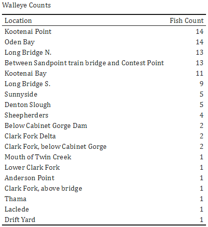
Check out June 7 Walleye Map to see specific numbers recorded at each receiver or view the table below.

Fishery biologists will continue tracking walleyes all summer and will periodically provide location data with maps to help anglers better target walleyes and help us manage this complex fishery. More information about fishery work occurring on Lake Pend Oreille can be found on the Lake Pend Oreille Fisheries website or by calling your local regional office.

