Fish and Game biologists initiated a pilot study in March 2018 to better understand walleye movement in Lake Pend Oreille. Walleye were tagged with transmitters that allow biologists to track their movements throughout the lake and rivers using telemetry. Although our sample size was small during the first year, the study already has revealed some important general patterns:
- Walleye primarily occupy the rivers and northern portion of the lake during all seasons.
- Walleye regularly move great distances throughout the system.
- Walleye are concentrated near the Pack River delta and Clark Fork River delta around the time of spawning but disperse widely after spawning and during the summer.
This year, our objective is to refine and intensify our walleye movement studies to learn more detailed information about spawning locations, spawn timing, seasonal movements, and habitat selection throughout the year. In March 2019, we began incorporating new telemetry technologies which will provide us with finer-scale information for these important factors. The new technologies include up to 30 stationary telemetry receivers placed at key locations around the lake and in the Clark Fork and Pend Oreille rivers that will document when a tagged walleye passes by a receiver. At the end of the season we will download information from all of the receivers to evaluate individual walleye movements throughout the entire system.
Results as of May 2019
The map below provides walleye telemetry locations during the month of May. All locations are based on results from downloading stationary receivers but we will soon be actively tracking walleye from a boat as well, focusing on areas in shallow bays where we currently do not have any stationary receivers. We will add walleye locations based on active telemetry tracking to subsequent maps.
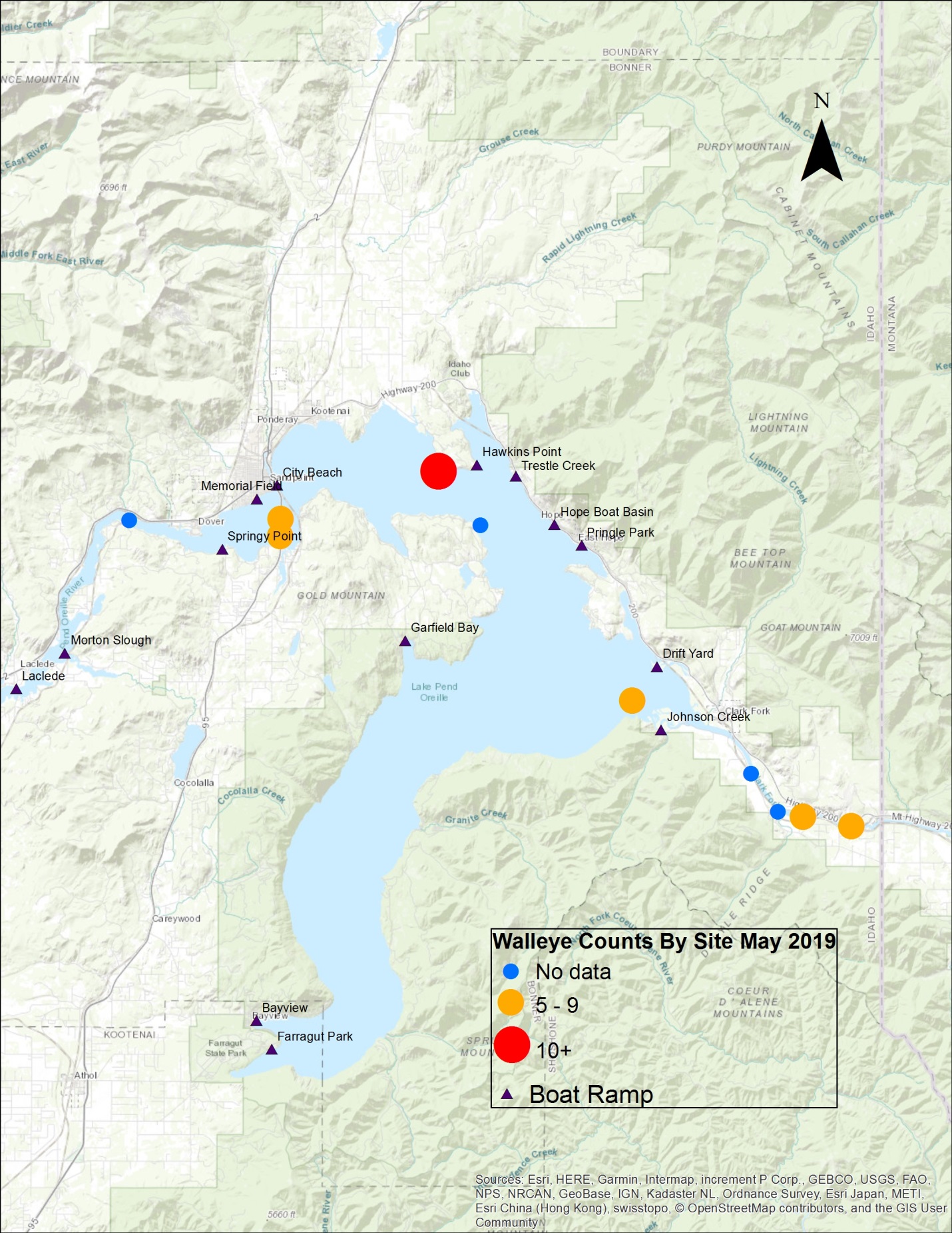
Early results from our new telemetry program indicate that during May walleye were concentrated in the upper Clark Fork River, at the Clark Fork River delta and the Sunnyside area. In addition, several walleye had already started moving west to the Sandpoint long bridge area. Based on last year, we expect walleye will begin concentrating near the Sandpoint long bridge in June and angling should continue to improve in coming weeks.
If you catch a walleye that contains a transmitter inside its stomach please return it to the F&G Panhandle regional office (IDFG-Fish Research, 2885 W. Kathleen Avenue, Coeur d’Alene, Idaho, 83815) so we can implant it into another walleye. These tags do not come with a reward under the Angler Incentive Program.
Maintaining stationary receivers in the lake and rivers can be difficult, as high flows and debris can dislodge them from their mooring. If you see a receiver attached to the bank, please leave it alone. If you find one that is obviously not where it was deployed, call the IDFG regional office at 208-769-1414 and let us know. Your cooperation will allow us to learn more about the walleye population and provide the best possible information to anglers.
In the short term, we plan to download several receivers in the northern part of the lake extending from the Clark Fork River west to Sandpoint and downstream into the Pend Oreille River to provide anglers with timely information on where walleye are concentrated. Our goal is to provide a map about every two to three weeks on the most current walleye hot spots.
Our long-term goal is to continue improving our understanding of how walleye use the Lake Pend Oreille system to help guide future management actions. In the short-term, we hope this walleye telemetry information will help anglers to more easily find and catch walleye. We hope angling will be an effective tool for keeping walleye numbers in check, like it has been for lake trout.
Keep checking back for the latest maps. Good fishing!