Walleye were illegally introduced into Noxon Reservoir (Montana) in the early 1990’s. Noxon Reservoir is upstream of Lake Pend Oreille on the Clark Fork River. Walleye spawn below Thompson Falls Dam (the upstream end of Noxon Reservoir) and their fry naturally drift downstream after hatching, which is likely how they got into Lake Pend Oreille. Walleye were first detected at low densities in Lake Pend Oreille in the mid-2000s and their densities have been rapidly increasing in recent years.
Walleye are highly-effective predators, and in Lake Pend Oreille they commonly feed on kokanee in the deeper parts of the lake and yellow perch in the shallower areas. IDFG is concerned that walleye abundance may continue to increase to the point where they cause excessive predation on kokanee and compete with or reduce abundance of highly-valued sport fish species, such as rainbow trout and bass, as well as native bull trout and cutthroat trout.
To understand general walleye movements throughout Lake Pend Oreille, IDFG biologists initiated a telemetry study in March 2018. Twenty-one walleye were tagged with transmitters to allow biologists to identify general movements throughout the lake and rivers.
Our spring update () summarized telemetry information from March through June. During March through early-May, we identified major walleye concentrations near the Clark Fork River delta and near Sunnyside to the mouth of Pack River. By mid-May, several walleye were documented moving upstream into the Clark Fork River, some as far upstream as the Cabinet Gorge Dam. Later in the spring after spawning, several tagged walleye were located in Denton Slough, while others were concentrated around Sandpoint near the railroad and Highway 95 bridges, Oden bay, Ponder Point, and Kootenai Point.
Results from early-July to early-September tracking confirm that some walleye in Lake Pend Oreille (and the Clark Fork and Pend Oreille rivers) migrate many miles, while others tend to occupy a smaller area. For example, one walleye was tagged below the Dover railroad bridge in fall 2017, migrated to the Clark Fork River by late-April 2018 before returning to the Pend Oreille River in July of 2018. In contrast, three walleye moved from the Clark Fork River to Denton Slough where they stayed through at least early September, when the tags expired. Our summer tracking suggests that the Clark Fork River and delta, Denton Slough, the bridges around and below Sandpoint, and the deeper holes in the Pend Oreille River are areas most used by walleye during the summer.
walleye transmitters expired in mid-September and the pilot-portion of this walleye movement research has concluded. Although our sample size was small, our pilot-telemetry studies have already revealed some important general patterns. First, walleye primarily occupy the rivers and northern portion of the lake during all seasons. Second, walleye regularly move great distances throughout the system. Third, walleye are concentrated in two localized areas around the time of spawning but disperse widely after spawning and during the summer. Our next objective is to refine and intensify our walleye movement studies to learn more detail about spawning locations, spawn timing, seasonal movements, and habitat selection throughout the year. We will be incorporating some new technologies in 2019 which will enable us to provide better seasonal information for these important factors. Our goal is to continue improving our understanding of how walleye use the Lake Pend Oreille system to make informed management decisions moving forward. This research will also help us to guide anglers on where the best areas are to fish for walleyes and when. attached map (Figure 1) shows telemetry locations of walleye from early-July to early-September.
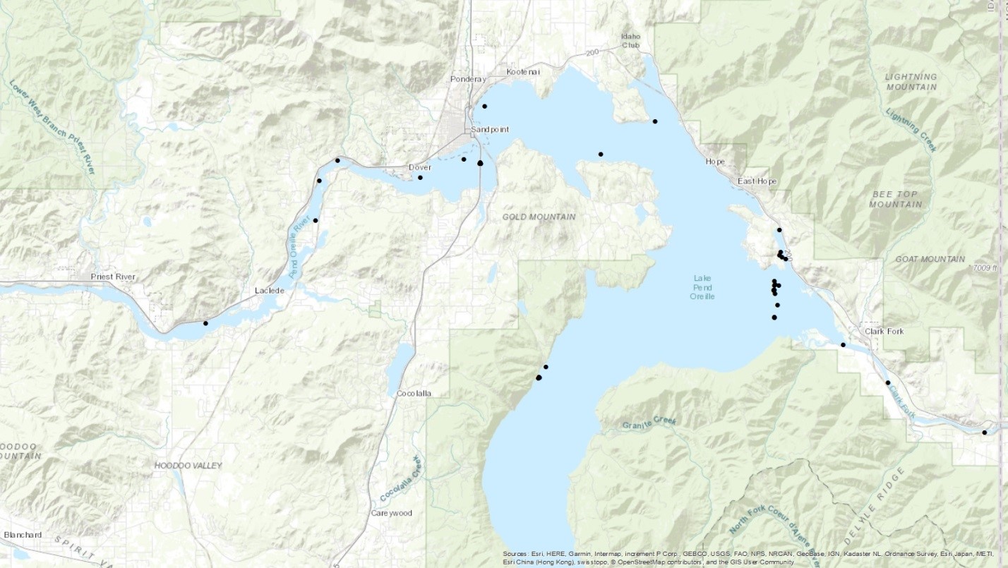
Figure 1. Telemetry locations of radio and sonic tagged walleyes in Lake Pend Oreille from early-July through early-September 2018.