Idaho Hunt Planner We got game.
Unit 50
- Region 6
- Upper Snake Region
- Pioneer Elk Zone
- Units 36A, 49, 50
Game Management Unit Boundary
Those portions of BLAINE, BUTTE, and CUSTER COUNTIES within the Big Lost River drainage north of U.S. 20-26 and State Highway 33, and the area east of Lava Lake and Copper Creek and north of U.S. 20-26. CRATERS OF THE MOON NATIONAL MONUMENT-CLOSED.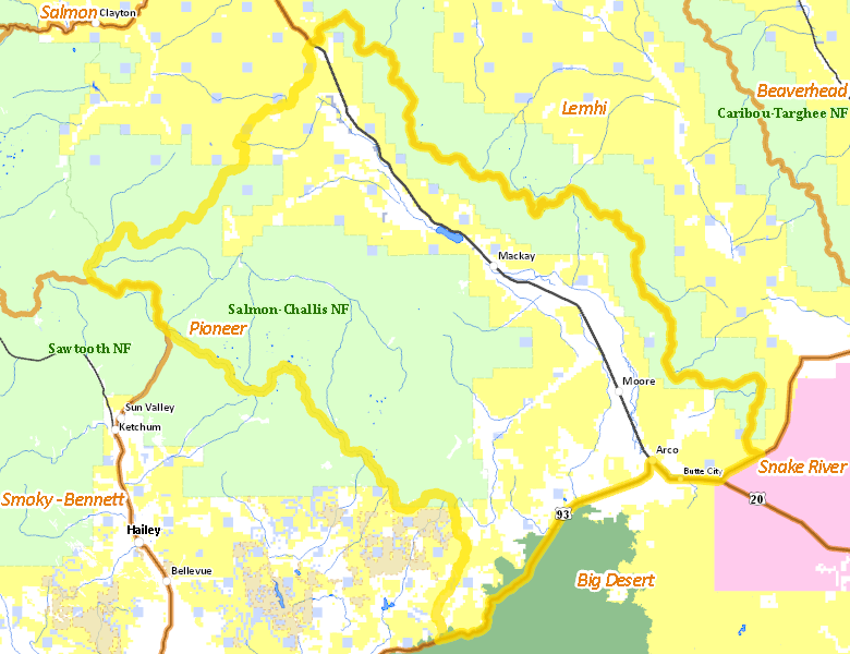
Public Access
Surface Management
For government land, these data show the managing agency of the land, which may or not be the same as the owning agency.
| U.S. Forest Service (USFS) |  50.62
%
50.62
%
|
| U.S. Bureau of Land Management (BLM) |
29.31
%
|
| Private |
17.43
%
|
| State of Idaho |
1.66
%
|
| U.S. National Park Service (NPS) |
0.97
%
|
| U.S. Department of Energy (DOE) |
0.01
%
|
Make your own map of Unit 50
Ownership data source: Inside Idaho
Access Yes! Properties
No properties are currently available in Unit 50.
View all Access Yes Participants.
National Forests
Federally-designated Wilderness Areas
No motorized vehicles are allowed in these areas.
There are no wilderness areas in Unit 50.
Land Use/Cover
| Rangeland |
73.6
%
|
| Forest |
11.52
%
|
| Irrigated-Sprinkler |
6.64
%
|
| Irrigated-Gravity Flow |
5.11
%
|
| Riparian |
1.81
%
|
| Rock |
1.21
%
|
| Water |
0.12
%
|
Make your own map of Unit 50
Land Use data source: IDWR