Idaho Hunt Planner We got game.
Unit 1
- Region 1
- Panhandle Region
- Panhandle Elk Zone
- Units 1, 2, 3, 4, 4A, 5, 6, 7, 9
Game Management Unit Boundary
All of BOUNDARY COUNTY and that portion of BONNER COUNTY north of the Pend Oreille River, Pend Oreille Lake and Clark Fork River. MYRTLE CREEK AND DAVID THOMPSON GAME PRESERVES - CLOSED.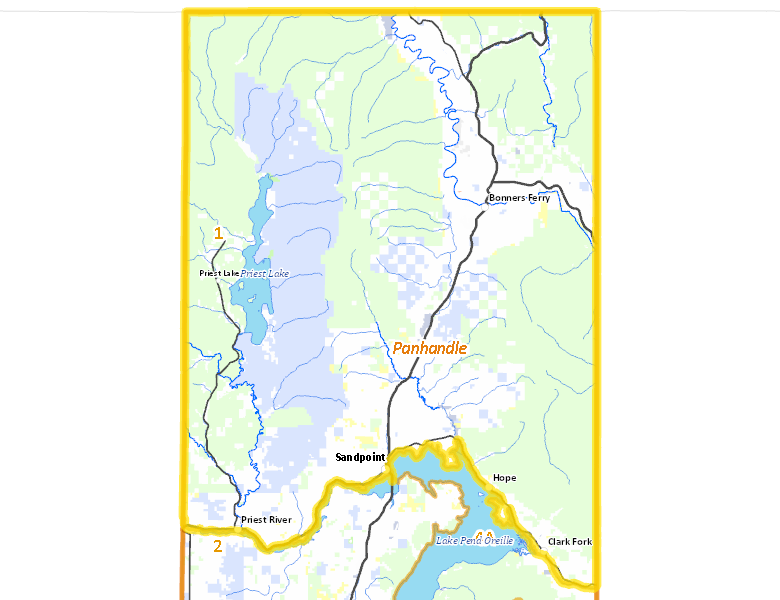
Public Access
Surface Management
For government land, these data show the managing agency of the land, which may or not be the same as the owning agency.
| U.S. Forest Service (USFS) |  52.24
%
52.24
%
|
| Private |
29.19
%
|
| State of Idaho |
15.64
%
|
| Other |
2.09
%
|
| U.S. Bureau of Land Management (BLM) |
0.73
%
|
| Indian Reservation / Bureau of Indian Affairs |
0.1
%
|
Make your own map of Unit 1
Ownership data source: Inside Idaho
Access Yes! Properties
No properties are currently available in Unit 1.
View all Access Yes Participants.
National Forests
Federally-designated Wilderness Areas
No motorized vehicles are allowed in these areas.
There are no wilderness areas in Unit 1.
Land Use/Cover
| Forest |
77.62
%
|
| Dryland Agriculture |
14.43
%
|
| Rangeland |
6.13
%
|
| Water |
1.63
%
|
| Urban |
0.16
%
|
Make your own map of Unit 1
Land Use data source: IDWR