Idaho Hunt Planner We got game.
Hunt Area
All of Unit 38 except that portion of Unit 38 within the Lake Lowell Sector of the Deer Flat National Wildlife Refuge is closed.
More information about the Game Management Unit(s) in this area: 38 38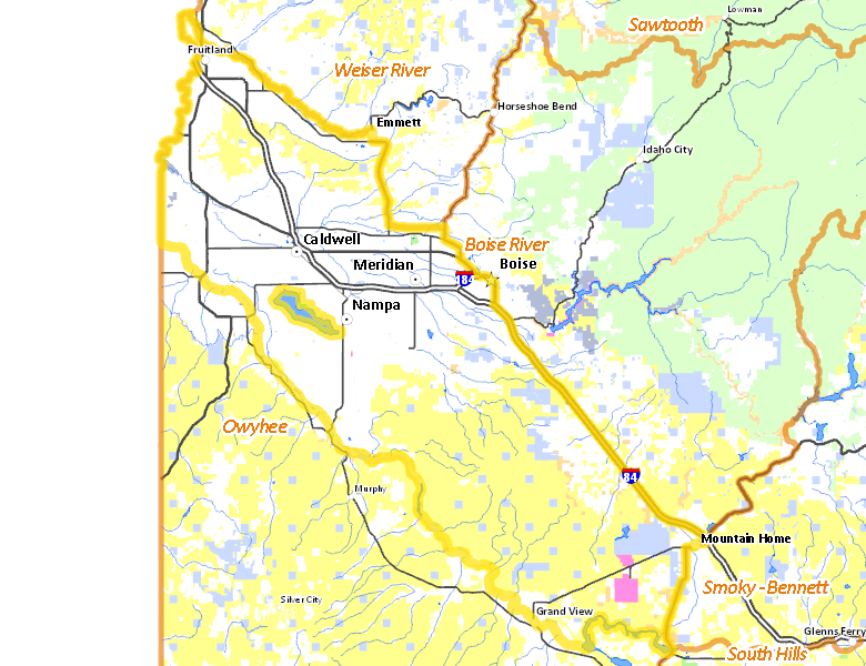
Recent Hunts in this Area
| Year | Tag | Open | Close | Take Method | Game | Area |
|---|---|---|---|---|---|---|
| 2026 | Regular Deer Tag | 10/10/2026 | 10/31/26 | Short-Range Weapons | Mule and White-tailed Deer | Unit 38, except Lake Lowell Sector of Deer Flat NWR |
| 2026 | Regular Deer Tag | 10/10/2026 | 11/24/26 | Short-Range Weapons | Mule and White-tailed Deer | Unit 38, except Lake Lowell Sector of Deer Flat NWR |
| 2026 | White-tailed Deer Tag | 10/10/2026 | 10/31/26 | Short-Range Weapons | White-tailed Deer | Unit 38, except Lake Lowell Sector of Deer Flat NWR |
| 2026 | White-tailed Deer Tag | 10/10/2026 | 11/24/26 | Short-Range Weapons | White-tailed Deer | Unit 38, except Lake Lowell Sector of Deer Flat NWR |
| 2026 | Deer Controlled Hunt 1029 | 10/10/2026 | 11/24/26 | Short-Range Weapons | Mule and White-tailed Deer | Area 38-2 |
| 2026 | Regular Deer Tag | 8/30/2026 | 9/30/26 | Archery | Mule and White-tailed Deer | Unit 38, except Lake Lowell Sector of Deer Flat NWR |
| 2026 | White-tailed Deer Tag | 8/30/2026 | 9/30/26 | Archery | White-tailed Deer | Unit 38, except Lake Lowell Sector of Deer Flat NWR |
| 2025 | Regular Deer Tag | 10/10/2025 | 10/31/25 | Short-Range Weapons | Mule and White-tailed Deer | Unit 38, except Lake Lowell Sector of Deer Flat NWR |
| 2025 | Regular Deer Tag | 10/10/2025 | 11/24/25 | Short-Range Weapons | Mule and White-tailed Deer | Unit 38, except Lake Lowell Sector of Deer Flat NWR |
| 2025 | White-tailed Deer Tag | 10/10/2025 | 10/31/25 | Short-Range Weapons | White-tailed Deer | Unit 38, except Lake Lowell Sector of Deer Flat NWR |
| 2025 | White-tailed Deer Tag | 10/10/2025 | 11/24/25 | Short-Range Weapons | White-tailed Deer | Unit 38, except Lake Lowell Sector of Deer Flat NWR |
| 2025 | Deer Controlled Hunt 1029 | 10/10/2025 | 11/24/25 | Short-Range Weapons | Mule and White-tailed Deer | Area 38-2 |
| 2025 | Regular Deer Tag | 8/30/2025 | 9/30/25 | Archery | Mule and White-tailed Deer | Unit 38, except Lake Lowell Sector of Deer Flat NWR |
| 2025 | White-tailed Deer Tag | 8/30/2025 | 9/30/25 | Archery | White-tailed Deer | Unit 38, except Lake Lowell Sector of Deer Flat NWR |
| 2024 | Regular Deer Tag | 10/10/2024 | 10/31/24 | Short-Range Weapons | Mule and White-tailed Deer | Unit 38, except Lake Lowell Sector of Deer Flat NWR |
| 2024 | Regular Deer Tag | 10/10/2024 | 11/24/24 | Short-Range Weapons | Mule and White-tailed Deer | Unit 38, except Lake Lowell Sector of Deer Flat NWR |
| 2024 | White-tailed Deer Tag | 10/10/2024 | 10/31/24 | Short-Range Weapons | White-tailed Deer | Unit 38, except Lake Lowell Sector of Deer Flat NWR |
| 2024 | White-tailed Deer Tag | 10/10/2024 | 11/24/24 | Short-Range Weapons | White-tailed Deer | Unit 38, except Lake Lowell Sector of Deer Flat NWR |
| 2024 | Deer Controlled Hunt 1029 | 10/10/2024 | 11/24/24 | Short-Range Weapons | Mule and White-tailed Deer | Area 38-2 |
| 2024 | Regular Deer Tag | 8/30/2024 | 9/30/24 | Archery | Mule and White-tailed Deer | Unit 38, except Lake Lowell Sector of Deer Flat NWR |
| 2024 | White-tailed Deer Tag | 8/30/2024 | 9/30/24 | Archery | White-tailed Deer | Unit 38, except Lake Lowell Sector of Deer Flat NWR |
Surface Management
For government land, these data show the managing agency of the land, which may or not be the same as the owning agency.
 Private 58.99%
|
|
U.S. Bureau of Land Management (BLM) 32.84%
|
|
State of Idaho 5.04%
|
|
Other 1.16%
|
|
U.S. Bureau of Reclamation (BOR) 1.1%
|
|
U.S. Military 0.62%
|
|
U.S. National Wildlife Refuge (NWR) 0.06%
|
Make your own map of Hunt Area
Ownership data source: Inside Idaho
Access Yes! Properties
Access Yes! is Fish and Game program designed to improve hunting and fishing access to private land or through private land to public land by compensating willing landowners who provide access.
No properties are currently available in .
View all Access Yes Participants.
Forest Service Land
Check for road and area closures on National Forest websites
No National Forest lands fall within .
Federally-designated Wilderness Areas
No motorized vehicles are allowed in these areas.
There are no wilderness areas in .
Land Use/Land Cover
|
Rangeland
47.03
%
|
|
Irrigated-Gravity Flow
36.1
%
|
|
Irrigated-Sprinkler
7.9
%
|
|
Urban
5.66
%
|
|
Dryland Agriculture
2.38
%
|
|
Riparian
0.49
%
|
|
Water
0.41
%
|
Make your own map of Hunt Area
Land Use data source: IDWR
Towns in this Hunt Area
- Boise, Interstate 84 Idaho 55 Idaho 21
- Nampa, Interstate 84 Idaho 55
- Meridian, Interstate 84 US 20-26
- Caldwell, Interstate 84 US 20-26 Idaho 55
- Eagle, Idaho 55 Idaho 44
- Mountain Home, Interstate 84 US 20 Idaho 51
- Garden City, Idaho 55 Interstate 84
- Kuna, Idaho 69
- Emmett, Idaho 52
- Fruitland, US 30 US 95
- Homedale, US 95
- Parma, US 95
- Wilder, US 95
- New Plymouth, Idaho 52 US 30
- Grand View, Idaho 78