Idaho Hunt Planner We got game.
Hunt Area
All of Unit 63.
More information about the Game Management Unit(s) in this area: 63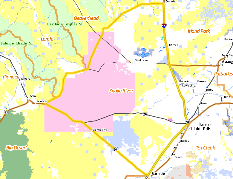
Recent Hunts in this Area
| Year | Tag | Open | Close | Take Method | Game | Area |
|---|---|---|---|---|---|---|
| 2026 | White-tailed Deer Tag | 11/1/2026 | 12/19/26 | Archery | White-tailed Deer | Unit 63 |
| 2026 | Elk Controlled Hunt 2170 | 11/1/2026 | 12/31/26 | Any Weapon | Elk | Area 63X |
| 2026 | Regular Deer Tag | 10/10/2026 | 10/24/26 | Short-Range Weapons | Mule and White-tailed Deer | Unit 63 |
| 2026 | White-tailed Deer Tag | 10/10/2026 | 10/31/26 | Short-Range Weapons | White-tailed Deer | Unit 63 |
| 2026 | White-tailed Deer Tag | 10/10/2026 | 10/31/26 | Short-Range Weapons | White-tailed Deer | Unit 63 |
| 2026 | Elk Controlled Hunt 2100 | 9/1/2026 | 12/31/26 | Any Weapon | Elk | Area 63 |
| 2026 | Elk Controlled Hunt 2120 | 8/31/2026 | 11/30/26 | Any Weapon | Elk | Area 63 |
| 2026 | Regular Deer Tag | 8/30/2026 | 9/30/26 | Archery | Mule and White-tailed Deer | Unit 63 |
| 2026 | White-tailed Deer Tag | 8/30/2026 | 9/30/26 | Archery | White-tailed Deer | Unit 63 |
| 2026 | Elk Controlled Hunt 2119 | 8/1/2026 | 8/30/26 | Any Weapon | Elk | Area 63 |
| 2026 | Elk Controlled Hunt 2169 | 8/1/2026 | 10/31/26 | Any Weapon | Elk | Area 63X |
| 2025 | General Black Bear Tag | 7/1/2026 | 7/31/26 | Dog Training | Black Bear | Unit 63 |
| 2025 | General Black Bear Tag | 4/15/2026 | 6/30/26 | Any Weapon | Black Bear | Unit 63 |
| 2025 | White-tailed Deer Tag | 11/1/2025 | 12/19/25 | Archery | White-tailed Deer | Unit 63 |
| 2025 | Elk Controlled Hunt 2170 | 11/1/2025 | 12/31/25 | Any Weapon | Elk | Area 63X |
| 2025 | Regular Deer Tag | 10/10/2025 | 10/24/25 | Short-Range Weapons | Mule and White-tailed Deer | Unit 63 |
| 2025 | White-tailed Deer Tag | 10/10/2025 | 10/31/25 | Short-Range Weapons | White-tailed Deer | Unit 63 |
| 2025 | White-tailed Deer Tag | 10/10/2025 | 10/31/25 | Short-Range Weapons | White-tailed Deer | Unit 63 |
| 2025 | Elk Controlled Hunt 2100 | 9/1/2025 | 12/31/25 | Any Weapon | Elk | Area 63 |
| 2025 | Elk Controlled Hunt 2120 | 8/31/2025 | 11/30/25 | Any Weapon | Elk | Area 63 |
| 2025 | Regular Deer Tag | 8/30/2025 | 9/30/25 | Archery | Mule and White-tailed Deer | Unit 63 |
| 2025 | White-tailed Deer Tag | 8/30/2025 | 9/30/25 | Archery | White-tailed Deer | Unit 63 |
| 2025 | General Black Bear Tag | 8/30/2025 | 10/31/25 | Any Weapon | Black Bear | Unit 63 |
| 2025 | Elk Controlled Hunt 2119 | 8/1/2025 | 8/30/25 | Any Weapon | Elk | Area 63 |
| 2025 | Elk Controlled Hunt 2169 | 8/1/2025 | 10/31/25 | Any Weapon | Elk | Area 63X |
| 2024 | Black Bear Tag | 7/1/2025 | 7/31/25 | Dog Training | Black Bear | Unit 63 |
| 2025 | General Mountain Lion Tag | 7/1/2025 | 6/30/26 | Any Weapon | Mountain Lion | Unit 63 |
| 2024 | Black Bear Tag | 4/15/2025 | 6/30/25 | Any Weapon | Black Bear | Unit 63 |
| 2024 | White-tailed Deer Tag | 11/1/2024 | 12/19/24 | Archery | White-tailed Deer | Unit 63 |
| 2024 | Elk Controlled Hunt 2161 | 11/1/2024 | 12/31/24 | Any Weapon | Elk | Area 63X |
| 2024 | Regular Deer Tag | 10/10/2024 | 10/24/24 | Short-Range Weapons | Mule and White-tailed Deer | Unit 63 |
| 2024 | White-tailed Deer Tag | 10/10/2024 | 10/31/24 | Short-Range Weapons | White-tailed Deer | Unit 63 |
| 2024 | White-tailed Deer Tag | 10/10/2024 | 10/31/24 | Short-Range Weapons | White-tailed Deer | Unit 63 |
| 2024 | Elk Controlled Hunt 2098 | 9/1/2024 | 12/31/24 | Any Weapon | Elk | Area 63 |
| 2024 | Elk Controlled Hunt 2114 | 8/31/2024 | 11/30/24 | Any Weapon | Elk | Area 63 |
| 2024 | Regular Deer Tag | 8/30/2024 | 9/30/24 | Archery | Mule and White-tailed Deer | Unit 63 |
| 2024 | White-tailed Deer Tag | 8/30/2024 | 9/30/24 | Archery | White-tailed Deer | Unit 63 |
| 2024 | Black Bear Tag | 8/30/2024 | 10/31/24 | Any Weapon | Black Bear | Unit 63 |
| 2024 | Mountain Lion Tag | 8/30/2024 | 3/31/25 | Any Weapon | Mountain Lion | Unit 63 |
| 2024 | Elk Controlled Hunt 2113 | 8/1/2024 | 8/30/24 | Any Weapon | Elk | Area 63 |
| 2024 | Elk Controlled Hunt 2160 | 8/1/2024 | 10/31/24 | Any Weapon | Elk | Area 63X |
| 2024 | Black Bear Tag | 7/1/2024 | 7/31/24 | Dog Training | Black Bear | Unit 63 |
Surface Management
For government land, these data show the managing agency of the land, which may or not be the same as the owning agency.
 U.S. Department of Energy (DOE) 35.6%
|
|
Private 35.58%
|
|
U.S. Bureau of Land Management (BLM) 20.89%
|
|
State of Idaho 7.5%
|
|
Other 0.19%
|
|
U.S. National Wildlife Refuge (NWR) 0.16%
|
|
U.S. Military 0.08%
|
Make your own map of Hunt Area
Ownership data source: Inside Idaho
Access Yes! Properties
Access Yes! is Fish and Game program designed to improve hunting and fishing access to private land or through private land to public land by compensating willing landowners who provide access.
No properties are currently available in .
View all Access Yes Participants.
Forest Service Land
Check for road and area closures on National Forest websites
No National Forest lands fall within .
Federally-designated Wilderness Areas
No motorized vehicles are allowed in these areas.
There are no wilderness areas in .
Land Use/Land Cover
|
Rangeland
60.03
%
|
|
Irrigated-Sprinkler
20.79
%
|
|
Irrigated-Gravity Flow
8.42
%
|
|
Rock
7.65
%
|
|
Riparian
1.74
%
|
|
Dryland Agriculture
1.23
%
|
|
Urban
0.14
%
|
Make your own map of Hunt Area
Land Use data source: IDWR