Idaho Hunt Planner We got game.
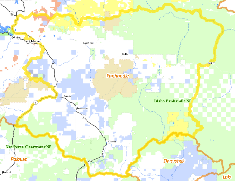
Unit 6
- Region 1
- Panhandle Region
- Panhandle Elk Zone
- Units 1, 2, 3, 4, 4A, 5, 6, 7, 9
Game Management Unit Boundary
Those portions of KOOTENAI, SHOSHONE, BENEWAH, CLEARWATER, and LATAH COUNTIES within the following boundary: beginning at St. Maries, then downstream along the northern bank of the St. Joe River to Mission Point on State Highway 3, then north on State Highway 3 to the watershed divide between the St. Joe and Coeur d’Alene Rivers, then east along the divide to the Moon Pass Road, then south on Moon Pass Road to Avery, then west on the St. Joe River Road to the Fishhook CreekRoad (Forest Service Road 301), then south on Fishhook Creek Road to Breezy Saddle, then southwest on Forest Service Road 301 to White Rock Springs, then south along the watershed divide between the St. Maries River and Little North Fork of the Clearwater River over Stony Butte to Hemlock Butte, then northwest along the St. Maries River- Potlatch River watershed divide across Bald Mountain to State Highway 6, then northeast on State Highway 6 to the intersection of State Highway 3, then north on State Highway 3 to the St. Maries River, then downstream to St. Maries, the point of beginning.
Public Access
Surface Management
For government land, these data show the managing agency of the land, which may or not be the same as the owning agency.
| Private |  44.12
%
44.12
%
|
| U.S. Forest Service (USFS) |
41.64
%
|
| State of Idaho |
10.06
%
|
| U.S. Bureau of Land Management (BLM) |
3.44
%
|
| Indian Reservation / Bureau of Indian Affairs |
0.49
%
|
| Other |
0.24
%
|
Make your own map of Unit 6
Ownership data source: Inside Idaho
Access Yes! Properties
National Forests
Federally-designated Wilderness Areas
No motorized vehicles are allowed in these areas.
There are no wilderness areas in Unit 6.
Land Use/Cover
| Forest |
84.42
%
|
| Rangeland |
12.38
%
|
| Dryland Agriculture |
3.2
%
|
Make your own map of Unit 6
Land Use data source: IDWR