Idaho Hunt Planner We got game.
Hunt Area
That portion of Unit 16A north and west of the following boundary: Beginning at Anderson Butte, then east along the Drive Ridge Trail (Forest Service Trail 809) to the Meadow Creek Trail (Forest Service Trail 726), then east along the Meadow Creek Trail to the Disgrace Butte-Vermilion Peak Trail (Forest Service Trail 609), then northeast along the Disgrace Butte-Vermilion Peak Trail to the Buck Lake Creek-Drake Creek Trail (Forest Service Trail 628), then northeast along the Buck Lake Creek-Drake Creek Trail to the Unit 16A boundary at Drake Saddle.
More information about the Game Management Unit(s) in this area: 15 15 16 16A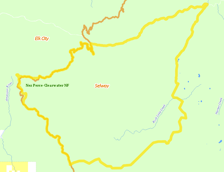
Surface Management
For government land, these data show the managing agency of the land, which may or not be the same as the owning agency.
 U.S. Forest Service (USFS) 99.77%
|
|
Other 0.23%
|
Make your own map of Hunt Area
Ownership data source: Inside Idaho
Access Yes! Properties
Access Yes! is Fish and Game program designed to improve hunting and fishing access to private land or through private land to public land by compensating willing landowners who provide access.
No properties are currently available in .
View all Access Yes Participants.
Forest Service Land
Check for road and area closures on National Forest websites
Federally-designated Wilderness Areas
No motorized vehicles are allowed in these areas.
- Selway Bitterroot Wilderness 23,414 acres (26.57% of hunt area)
Land Use/Land Cover
|
Forest
83.82
%
|
|
Rangeland
16.18
%
|
Make your own map of Hunt Area
Land Use data source: IDWR
Towns in this Hunt Area
No services are available inside .
Services courtesy of the Official Idaho Travel and Tourism Guide