Idaho Hunt Planner We got game.
Hunt Area
That portion of Unit 30A starting at the junction of Highway 28 and Highway 29 and continuing east on Highway 29 to the junction with the USFS administrative boundary. Then following the USFS boundary south to the junction with the Dry Canyon Road. Then west on the Dry Canyon Road to the junction with the 18 Mile Road. Then south along the 18 Mile Road to the junction with the Clear Creek Road. Then west on the Clear Creek Road to the Junction with the 18 Mile Road. Then west on the 18 Mile Road to the junction with Highway 28. Then north on Highway 28 to the point of origin.
More information about the Game Management Unit(s) in this area: 30A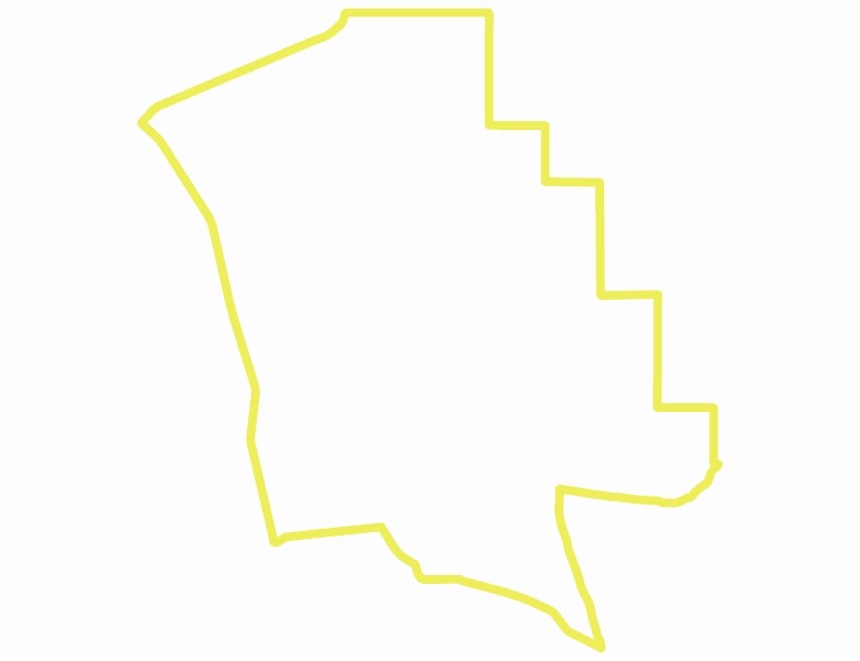
Recent Hunts in this Area
| Year | Tag | Open | Close | Take Method | Game | Area |
|---|---|---|---|---|---|---|
| 2026 | Elk Controlled Hunt 2111 | 8/1/2026 | 8/29/26 | Any Weapon | Elk | Area 30A-1 |
| 2025 | Elk Controlled Hunt 2111 | 8/1/2025 | 8/29/25 | Any Weapon | Elk | Area 30A-1 |
Surface Management
For government land, these data show the managing agency of the land, which may or not be the same as the owning agency.
No landownership for this area is available at this time.
Access Yes! Properties
Access Yes! is Fish and Game program designed to improve hunting and fishing access to private land or through private land to public land by compensating willing landowners who provide access.
No properties are currently available in .
View all Access Yes Participants.
Forest Service Land
Check for road and area closures on National Forest websites
No National Forest lands fall within .
Federally-designated Wilderness Areas
No motorized vehicles are allowed in these areas.
There are no wilderness areas in .
Land Use/Land Cover
No landcover for this area is available at this time.
Towns in this Hunt Area
No services are available inside .
Services courtesy of the Official Idaho Travel and Tourism Guide