Idaho Hunt Planner We got game.
Hunt Area
All of Unit 73A.
More information about the Game Management Unit(s) in this area: 73A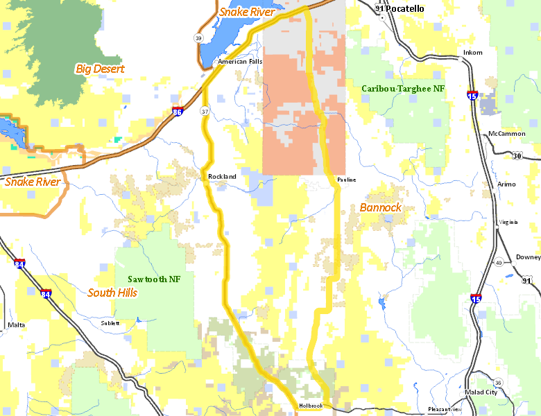
Recent Hunts in this Area
| Year | Tag | Open | Close | Take Method | Game | Area |
|---|---|---|---|---|---|---|
| 2026 | Deer Controlled Hunt 1097 | 11/16/2026 | 11/30/26 | Muzzleloader | Mule and White-tailed Deer | Area 73A |
| 2026 | Regular Deer Tag | 10/10/2026 | 10/24/26 | Muzzleloader | Mule and White-tailed Deer | Unit 73A |
| 2026 | Regular Deer Tag | 10/10/2026 | 10/24/26 | Archery | Mule and White-tailed Deer | Unit 73A |
| 2026 | Regular Deer Tag | 8/30/2026 | 9/30/26 | Archery | Mule and White-tailed Deer | Unit 73A |
| 2025 | General Black Bear Tag | 7/1/2026 | 7/31/26 | Dog Training | Black Bear | Unit 73A |
| 2025 | General Black Bear Tag | 4/15/2026 | 6/30/26 | Any Weapon | Black Bear | Unit 73A |
| 2025 | Deer Controlled Hunt 1097 | 11/16/2025 | 11/30/25 | Muzzleloader | Mule and White-tailed Deer | Area 73A |
| 2025 | Regular Deer Tag | 10/10/2025 | 10/24/25 | Archery | Mule and White-tailed Deer | Unit 73A |
| 2025 | Regular Deer Tag | 10/10/2025 | 10/24/25 | Muzzleloader | Mule and White-tailed Deer | Unit 73A |
| 2025 | Regular Deer Tag | 8/30/2025 | 9/30/25 | Archery | Mule and White-tailed Deer | Unit 73A |
| 2025 | General Black Bear Tag | 8/30/2025 | 10/31/25 | Any Weapon | Black Bear | Unit 73A |
| 2025 | Moose Controlled Hunt 3084 | 8/30/2025 | 11/23/25 | Any Weapon | Moose | Area 73A |
| 2025 | General Mountain Lion Tag | 7/1/2025 | 6/30/26 | Any Weapon | Mountain Lion | Unit 73A |
| 2024 | Deer Controlled Hunt 1099 | 11/16/2024 | 11/30/24 | Muzzleloader | Mule and White-tailed Deer | Area 73A |
| 2024 | Regular Deer Tag | 10/10/2024 | 10/24/24 | Any Weapon | Mule and White-tailed Deer | Unit 73A |
| 2024 | Regular Deer Tag | 8/30/2024 | 9/30/24 | Archery | Mule and White-tailed Deer | Unit 73A |
| 2024 | Mountain Lion Tag | 8/30/2024 | 3/31/25 | Any Weapon | Mountain Lion | Unit 73A |
| 2024 | Moose Controlled Hunt 3084 | 8/30/2024 | 11/23/24 | Any Weapon | Moose | Area 73A |
Surface Management
For government land, these data show the managing agency of the land, which may or not be the same as the owning agency.
 Private 48.91%
|
|
Indian Reservation / Bureau of Indian Affairs 23.13%
|
|
U.S. Bureau of Land Management (BLM) 19.95%
|
|
State of Idaho 4.05%
|
|
U.S. Department of Agriculture (USDA) 2.93%
|
|
U.S. Department of Interior (DOI) 0.76%
|
|
U.S. Forest Service (USFS) 0.27%
|
|
U.S. Bureau of Reclamation (BOR) 0%
|
Make your own map of Hunt Area
Ownership data source: Inside Idaho
Access Yes! Properties
Access Yes! is Fish and Game program designed to improve hunting and fishing access to private land or through private land to public land by compensating willing landowners who provide access.
No properties are currently available in .
View all Access Yes Participants.
Forest Service Land
Check for road and area closures on National Forest websites
Federally-designated Wilderness Areas
No motorized vehicles are allowed in these areas.
There are no wilderness areas in .
Land Use/Land Cover
|
Dryland Agriculture
46.45
%
|
|
Forest
25.79
%
|
|
Rangeland
20.33
%
|
|
Irrigated-Sprinkler
6.06
%
|
|
Irrigated-Gravity Flow
1.25
%
|
|
Urban
0.12
%
|
|
Riparian
0
%
|
Make your own map of Hunt Area
Land Use data source: IDWR
Towns in this Hunt Area
No services are available inside .
Services courtesy of the Official Idaho Travel and Tourism Guide