Idaho Hunt Planner We got game.
Hunt Area
All of Units 40 and 42 and that portion of Unit 41 west of Highway 51.
More information about the Game Management Unit(s) in this area: 40 41 42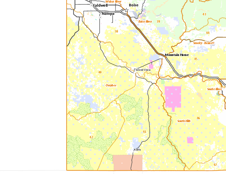
Recent Hunts in this Area
| Year | Tag | Open | Close | Take Method | Game | Area |
|---|---|---|---|---|---|---|
| 2026 | Elk Controlled Hunt 2083 | 10/15/2026 | 11/24/26 | Any Weapon | Elk | Area 40-1 |
| 2026 | Elk Controlled Hunt 2015 | 9/15/2026 | 10/14/26 | Any Weapon | Elk | Area 40-1 |
| 2026 | Elk Controlled Hunt 2123 | 9/15/2026 | 10/14/26 | Archery | Elk | Area 40-1 |
| 2026 | Elk Controlled Hunt 2190 | 9/15/2026 | 10/14/26 | Any Weapon | Elk | Area 40-1 |
| 2025 | Elk Controlled Hunt 2083 | 10/15/2025 | 11/24/25 | Any Weapon | Elk | Area 40-1 |
| 2025 | Elk Controlled Hunt 2015 | 9/15/2025 | 10/14/25 | Any Weapon | Elk | Area 40-1 |
| 2025 | Elk Controlled Hunt 2123 | 9/15/2025 | 10/14/25 | Archery | Elk | Area 40-1 |
| 2025 | Elk Controlled Hunt 2190 | 9/15/2025 | 10/14/25 | Any Weapon | Elk | Area 40-1 |
| 2024 | Elk Controlled Hunt 2081 | 10/15/2024 | 11/24/24 | Any Weapon | Elk | Area 40-1 |
| 2024 | Elk Controlled Hunt 2014 | 9/15/2024 | 10/14/24 | Any Weapon | Elk | Area 40-1 |
| 2024 | Elk Controlled Hunt 2117 | 9/15/2024 | 10/14/24 | Archery | Elk | Area 40-1 |
| 2024 | Elk Controlled Hunt 2181 | 9/15/2024 | 10/14/24 | Any Weapon | Elk | Area 40-1 |
Surface Management
For government land, these data show the managing agency of the land, which may or not be the same as the owning agency.
 U.S. Bureau of Land Management (BLM) 74.25%
|
|
Private 15.22%
|
|
State of Idaho 7.33%
|
|
Indian Reservation / Bureau of Indian Affairs 2.95%
|
|
U.S. Bureau of Reclamation (BOR) 0.21%
|
|
Other 0.04%
|
|
U.S. Military 0%
|
Make your own map of Hunt Area
Ownership data source: Inside Idaho
Access Yes! Properties
Access Yes! is Fish and Game program designed to improve hunting and fishing access to private land or through private land to public land by compensating willing landowners who provide access.
No properties are currently available in .
View all Access Yes Participants.
Forest Service Land
Check for road and area closures on National Forest websites
No National Forest lands fall within .
Federally-designated Wilderness Areas
No motorized vehicles are allowed in these areas.
- Owyhee River Wilderness 272,397 acres (8.7% of hunt area)
- Big Jacks Creek Wilderness 56,546 acres (1.81% of hunt area)
- Little Jacks Creek Wilderness 54,935 acres (1.76% of hunt area)
- North Fork Owyhee Wilderness 44,684 acres (1.43% of hunt area)
- Pole Creek Wilderness 13,405 acres (0.43% of hunt area)
Land Use/Land Cover
No landcover for this area is available at this time.
Towns in this Hunt Area
- Homedale, US 95
- Marsing, Idaho 55
- Grand View, Idaho 78
- Bruneau, Idaho 51
- Murphy, Idaho 78
- Silver City, Silver City Rd.