Idaho Hunt Planner We got game.
Hunt Area
That portion of Unit 27 southeast of the Middle Fork of the Salmon River, south and west of Camas Creek, northwest of Fly Creek Trail (Forest Service Trail 124), southwest of Sleeping Deer Road (Forest Service Rd 086), and east of Forest Service Road 172 and the Little Loon Creek drainage (includes all of this drainage).
More information about the Game Management Unit(s) in this area: 27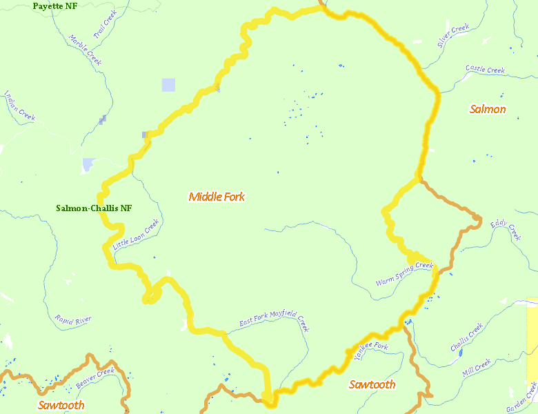
Recent Hunts in this Area
| Year | Tag | Open | Close | Take Method | Game | Area |
|---|---|---|---|---|---|---|
| 2025 | Rocky Mountain Bighorn Sheep Controlled Hunt 5011 | 8/30/2025 | 10/13/25 | Any Weapon | Rocky Mountain Bighorn Sheep | Area 27-4 |
| 2024 | Rocky Mountain Bighorn Controlled Hunt 5011 | 8/30/2024 | 10/13/24 | Any Weapon | Rocky Mountain Bighorn Sheep | Area 27-4 |
Surface Management
For government land, these data show the managing agency of the land, which may or not be the same as the owning agency.
 U.S. Forest Service (USFS) 99.81%
|
|
Private 0.11%
|
|
State of Idaho 0.06%
|
|
Other 0.02%
|
Make your own map of Hunt Area
Ownership data source: Inside Idaho
Access Yes! Properties
Access Yes! is Fish and Game program designed to improve hunting and fishing access to private land or through private land to public land by compensating willing landowners who provide access.
No properties are currently available in .
View all Access Yes Participants.
Forest Service Land
Check for road and area closures on National Forest websites
Federally-designated Wilderness Areas
No motorized vehicles are allowed in these areas.
- Frank Church - River of No Return Wilderness 298,029 acres (98.01% of hunt area)
Land Use/Land Cover
No landcover for this area is available at this time.
Towns in this Hunt Area
No services are available inside .
Services courtesy of the Official Idaho Travel and Tourism Guide