Idaho Hunt Planner We got game.
Hunt Area
That portion of Unit 53 east of US Highway 93. Due to routing changes made to US Highway 93, the western boundary for Unit 53 is: Beginning at the junction of US Highway 93 and US Highway 30 (east of Filer), north along Hwy 93 turning east at the junction of Poleline Road, continuing east to Blue Lakes Blvd, then north across the Perrine Bridge following US Highway 93 to US Highway 26 in Shoshone.
More information about the Game Management Unit(s) in this area: 53 53 53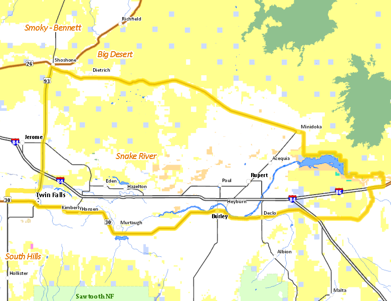
Recent Hunts in this Area
| Year | Tag | Open | Close | Take Method | Game | Area |
|---|---|---|---|---|---|---|
| 2026 | Deer Controlled Hunt 1079 | 8/30/2026 | 12/19/26 | Archery | Mule and White-tailed Deer | Area 53-1 |
| 2025 | Deer Controlled Hunt 1079 | 8/30/2025 | 12/19/25 | Archery | Mule and White-tailed Deer | Area 53-1 |
| 2024 | Deer Controlled Hunt 1081 | 8/30/2024 | 12/19/24 | Archery | Mule and White-tailed Deer | Area 53-1 |
Surface Management
For government land, these data show the managing agency of the land, which may or not be the same as the owning agency.
 Private 59.33%
|
|
U.S. Bureau of Land Management (BLM) 33.21%
|
|
U.S. Bureau of Reclamation (BOR) 3.8%
|
|
State of Idaho 2.21%
|
|
Other 1.13%
|
|
U.S. National Wildlife Refuge (NWR) 0.3%
|
|
U.S. National Park Service (NPS) 0.02%
|
Make your own map of Hunt Area
Ownership data source: Inside Idaho
Access Yes! Properties
Access Yes! is Fish and Game program designed to improve hunting and fishing access to private land or through private land to public land by compensating willing landowners who provide access.
No properties are currently available in .
View all Access Yes Participants.
Forest Service Land
Check for road and area closures on National Forest websites
No National Forest lands fall within .
Federally-designated Wilderness Areas
No motorized vehicles are allowed in these areas.
There are no wilderness areas in .
Land Use/Land Cover
No landcover for this area is available at this time.
Towns in this Hunt Area
- Twin Falls, Interstate 84 US 93 US 30
- Burley, Interstate 84 Idaho 27 US 30
- Rupert, Interstate 84 Idaho 24
- Heyburn, Interstate 84 US 30
- Shoshone, US 26 US 93 Idaho 24
- Minidoka, Idaho 24