Idaho Hunt Planner We got game.
Hunt Area
That portion of Unit 1 within the following boundaries: beginning on U.S. Highway 95 bridge across the Pend Oreille River at Sandpoint, then northward along Highway 95 to the Kootenai River at Bonner’s Ferry, then northwesterly along the Kootenai River to the U.S. border, then west along the U.S. border to the Priest River-Kootenai River divide, then south along the Priest River-Pack River divide to Flat Top Mountain, then south along the divide separating the Priest River drainage and the Pend Oreille drainage to Priest River, then east along the Pend Oreille River to the point of beginning.
More information about the Game Management Unit(s) in this area: 1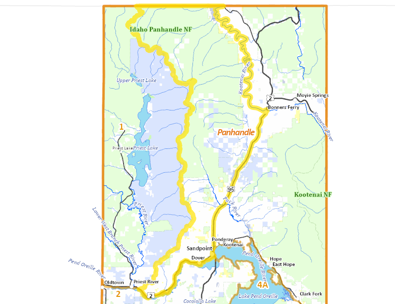
Recent Hunts in this Area
| Year | Tag | Open | Close | Take Method | Game | Area |
|---|---|---|---|---|---|---|
| 2025 | Moose Controlled Hunt 3006 | 11/1/2025 | 11/14/25 | Any Weapon | Moose | Area 1-2 |
| 2025 | Moose Controlled Hunt 3005 | 10/1/2025 | 10/14/25 | Any Weapon | Moose | Area 1-2 |
| 2025 | Moose Controlled Hunt 3004 | 9/15/2025 | 12/1/25 | Any Weapon | Moose | Area 1-2 |
| 2024 | Moose Controlled Hunt 3006 | 11/1/2024 | 11/14/24 | Any Weapon | Moose | Area 1-2 |
| 2024 | Moose Controlled Hunt 3005 | 10/1/2024 | 10/14/24 | Any Weapon | Moose | Area 1-2 |
| 2024 | Moose Controlled Hunt 3004 | 9/15/2024 | 12/1/24 | Any Weapon | Moose | Area 1-2 |
Surface Management
For government land, these data show the managing agency of the land, which may or not be the same as the owning agency.
No landownership for this area is available at this time.
Access Yes! Properties
Access Yes! is Fish and Game program designed to improve hunting and fishing access to private land or through private land to public land by compensating willing landowners who provide access.
No properties are currently available in .
View all Access Yes Participants.
Forest Service Land
Check for road and area closures on National Forest websites
No National Forest lands fall within .
Federally-designated Wilderness Areas
No motorized vehicles are allowed in these areas.
There are no wilderness areas in .
Land Use/Land Cover
No landcover for this area is available at this time.
Towns in this Hunt Area
No services are available inside .
Services courtesy of the Official Idaho Travel and Tourism Guide