Idaho Hunt Planner We got game.
Unit 46
- Region 4
- Magic Valley Region
- South Hills Elk Zone
- Units 46, 47, 54, 55, 56, 57
Game Management Unit Boundary
Those portions of ELMORE, OWYHEE, and TWIN FALLS COUNTIES within the following boundary: beginning at the State Highway 51 bridge on the Snake River, then upstream (INCLUDING ALL ISLANDS) to the Gridley Bridge across the Snake River near Hagerman, then southeast on U.S. 30 to U.S. 93, then south on U.S. 93 to Rogerson, then southwest on the Rogerson-Three Creek-Jarbidge Road to the Jarbidge River, then downstream to the West Fork of the Bruneau River, then downstream to the Bruneau River, then downstream to State Highway 51, then north on State Highway 51 to the Snake River, the point of beginning. THREE ISLAND STATE PARK AND ALL SNAKE RIVER ISLANDS BETWEEN THE GLENNS FERRY BRIDGE AND THE SLICK BRIDGE-CLOSED.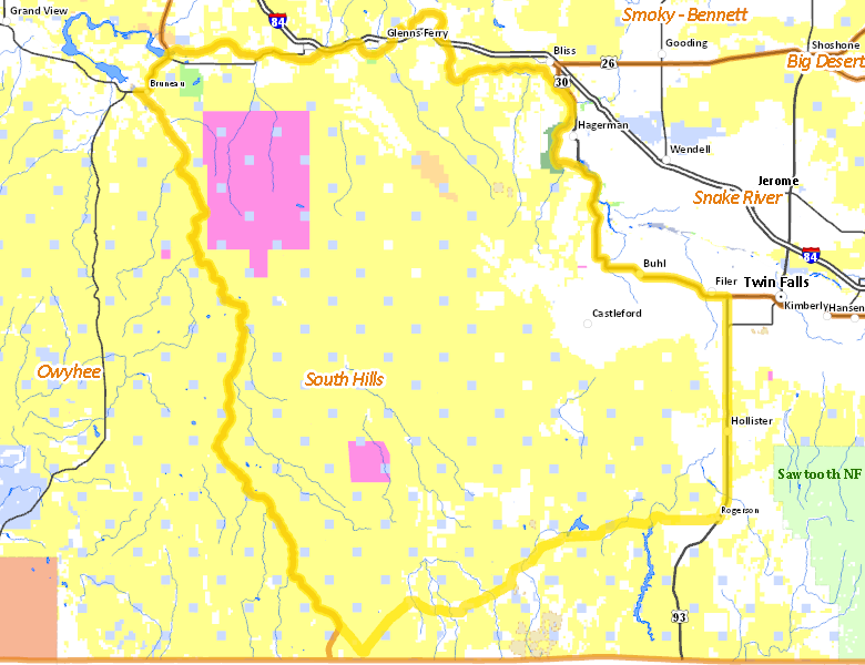
Public Access
Surface Management
For government land, these data show the managing agency of the land, which may or not be the same as the owning agency.
| U.S. Bureau of Land Management (BLM) |  70.04
%
70.04
%
|
| Private |
18.11
%
|
| U.S. Military |
6.75
%
|
| State of Idaho |
4.19
%
|
| U.S. Bureau of Reclamation (BOR) |
0.37
%
|
| Other |
0.3
%
|
| U.S. National Park Service (NPS) |
0.25
%
|
Make your own map of Unit 46
Ownership data source: Inside Idaho
Access Yes! Properties
National Forests
No National Forest lands fall within Unit 46.
Federally-designated Wilderness Areas
No motorized vehicles are allowed in these areas.
-
Bruneau-Jarbridge Rivers Wilderness
30,147 acres (1.77% of hunt area)
Land Use/Cover
| Rangeland |
83.84
%
|
| Irrigated-Gravity Flow |
6.46
%
|
| Irrigated-Sprinkler |
6.04
%
|
| Riparian |
2.61
%
|
| Urban |
0.72
%
|
| Rock |
0.2
%
|
| Dryland Agriculture |
0.12
%
|
| Water |
0.02
%
|
Make your own map of Unit 46
Land Use data source: IDWR