Idaho Hunt Planner We got game.
Hunt Area
Includes all parts of the state EXCEPT: all lands and waters within the Fort Hall Indian Reservation, including private in-holdings; and the following counties: Bannock, Bear Lake, Bingham, Bonneville, Butte, Caribou, Clark, Franklin, Fremont, Jefferson, Madison, Oneida, Payette, Power, Teton, Twin Falls, Valley, and Washington. NOTE: Fremont and Teton counties are closed.
More information about the Game Management Unit(s) in this area: 1 2 3 4 4A 5 6 7 8 8A 9 10 10A 11 11A 12 13 14 15 16 16A 17 18 19 19A 20 20A 21 21A 22 23 24 26 27 28 29 30 30A 31 32 32A 35 36 36A 36B 37 37A 43 44 45 48 49 50 51 52 52A 53 58 59A 68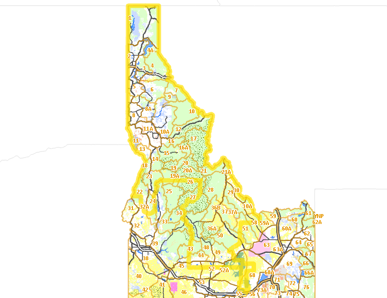
Surface Management
For government land, these data show the managing agency of the land, which may or not be the same as the owning agency.
 U.S. Forest Service (USFS) 57.73%
|
|
Private 24.13%
|
|
U.S. Bureau of Land Management (BLM) 10.3%
|
|
State of Idaho 4.23%
|
|
U.S. National Park Service (NPS) 0.96%
|
|
Other 0.88%
|
|
Indian Reservation / Bureau of Indian Affairs 0.56%
|
|
State of Idaho 0.53%
|
|
Indian Reservation / Bureau of Indian Affairs 0.43%
|
|
U.S. Corps of Engineers (COE) 0.09%
|
|
State of Idaho 0.07%
|
|
U.S. Bureau of Reclamation (BOR) 0.03%
|
|
U.S. National Wildlife Refuge (NWR) 0.01%
|
Make your own map of Hunt Area
Ownership data source: Inside Idaho
Access Yes! Properties
Access Yes! is Fish and Game program designed to improve hunting and fishing access to private land or through private land to public land by compensating willing landowners who provide access.
- Mica Creek Drainage on St. Joe River
- Hugas Creek & St. Joe River Basin
- Rinker Rock Creek Ranch
- Little Fish Creek Grazing Assoc.
- Telfer Inc.
- Robert Gardner
- Bob Ivie Property
- Janss Farms
Forest Service Land
Check for road and area closures on National Forest websites
- Targhee National Forest
- Boise National Forest
- Sawtooth National Forest
- Salmon National Forest
- Payette National Forest
- St. Joe National Forest
- Caribou National Forest
- Idaho Panhandle National Forest
- Cache National Forest
Federally-designated Wilderness Areas
No motorized vehicles are allowed in these areas.
- Frank Church - River of No Return Wilderness 1,625,911 acres (7.07% of hunt area)
- Selway Bitterroot Wilderness 1,092,240 acres (4.75% of hunt area)
- Gospel Hump Wilderness 205,589 acres (0.89% of hunt area)
- Hells Canyon Wilderness 86,379 acres (0.38% of hunt area)
- Sawtooth Wilderness 67,867 acres (0.3% of hunt area)
Land Use/Land Cover
No landcover for this area is available at this time.
Towns in this Hunt Area
- Coeur d'Alene, US 95 Interstate 90
- Lewiston, US 95 US 12
- Moscow, US 95
- Post Falls, Interstate 90
- Sandpoint, US 95 US 2 Idaho 200
- Hailey, Idaho 75
- Rathdrum, Idaho 53
- Sun Valley / Ketchum, Idaho 75
- Grangeville, US 95
- Orofino, US 12
- North Fork, US 93
- Salmon, US 93
- Bonners Ferry, US 95
- St. Maries, Idaho 3
- Cataldo, Interstate 90
- Kellogg, Interstate 90
- Bellevue, Idaho 75
- Murray / Prichard, Interstate 90
- Priest River, Idaho 57 US 2
- Spirit Lake, Idaho 41
- Kamiah, US 12
- Plummer, US 95
- Cottonwood, US 95
- Wallace, Interstate 90
- Challis, US 93
- Craigmont / Winchester, US 95
- Troy, Idaho 8
- Potlatch, Idaho 6 US 95
- Council, US 95
- Elk City, Idaho 14
- Athol, US 95 Interstate 90
- Kooskia, US 12 Idaho 13
- Hope / Clark Fork, Idaho 200
- Priest Lake, Idaho 57
- Pierce, Idaho 11
- Mackay, US 93
- Deary, Idaho 8
- New Meadows, US 95 Idaho 55
- Riggins, US 95
- Fairfield, US 20
- Weippe, Idaho 11
- Harrison, Idaho 97
- Worley, US 95
- Bayview, US 95
- Elk River, Idaho 8
- White Bird, US 95
- Stanley, Idaho 75 Idaho 21
- Leadore, Idaho 28 Idaho 29
- Lowell, US 12
- Blanchard, Idaho 41
- Picabo, US 20
- Tendoy, Idaho 28